Severe weather expected today for Jefferson Davis County
Published 5:32 am Wednesday, March 17, 2021
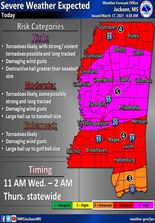
A very significant severe weather outbreak is expected across Mississippi today. A new high severe risk has been issued for the first time in the state since 2014.
There is a major concern for large, violent tornados to occur, especially in the high risk zone area. Severe straight-line wind gusts and large hail are also expected.
This will be an almost all-day event with multiple chances of seeing severe weather throughout St. Patrick’s Day.
Jefferson Davis County is in the moderate risk zone, but weather officials say that severe storms can and will happen, no matter the exact risk zone your county is under.
Jefferson Davis County Emergency Management Director Jocelyn Ragsdale advises residents to pay close attention to the weather today and heed all warnings and watches.
Weather.gov suggests checking flashlights and radios for fresh batteries, having cell phones fully charged and preparing a severe weather safety kit, if one is not already handy. Keep shoes on or nearby, along with personal ID and car keys.
When a tornado or severe thunderstorm watch is issued, it means conditions are favorable for such to develop. When a warning is issued, that means the potentially dangerous weather is headed in your direction.
When a severe thunderstorm warning is issued, move indoors away from windows, and monitor weather information closely.
When a tornado warning is issued, move quickly, get to shelter in the innermost room of the building or lowest floor. Get underground if possible. Number one killers from storms are flying and falling debris. Use pillows, coats, helmets, etc. to protect your head and body.
When a warning is issued, do not open windows or doors, do not seek shelter under a highway overpass and do not go outside looking for the tornado. None of these ideas is safe, according to NWS.